Review: CoPilot Live navigation app
As a cyclist that owns a smartphone, you may wonder – my phone comes preloaded with Google Maps, and that will easily get me from A to B when I need to cycle to a place that I do not know to get to – so why would I get anything else? CoPilot kindly offered me the chance to review their navigation app* and I decided to compare it to Google Maps.
All well and good, and for years I did just that, I used Google Maps to cycle to new places. I started to cycle to places using Google Maps just as they were airing the quaint adverts that informed us that Google Maps now includes cycling directions, provided by Sustrans. Remember these adverts: https://www.youtube.com/watch?v=1bFdNFTq8Vw ?
During that time I didn’t want for more, Google Maps seemed to be doing the trick nicely and I didn’t know that I was missing anything. Before too long, however, Google Maps did start to show some crack and I developed some niggles with it. The main problems are that:
- Maps (the actual pictures of the roads, etc) are loaded on-the-go over mobile internet, and Google Maps app doesn’t store any loaded maps, to my knowledge. This is problematic in two ways – it uses data allowance, but more annoyingly, if you’re in a bad reception area, sometimes the maps can take a minute or two to load. While you wait…
- There is no option to select what type of riding you want to do. Some cyclists want to use the main roads and tackle traffic, whilst others like to take the back roads. Google Maps is defaulted to the back roads and religiously sticks to the Sustrans bicycle paths. These are not always ideal – for example anytime you need to travel close to the river (Thames), Google Maps will send you down the canal pathways without fail. In fact, it will stubbornly direct you back to the canal pathways if you get away from them. Your mileage may vary, but those canal pathways are unsafe, full of pedestrians and more annoyingly, discontinuous, which makes them useless. I’d rather joust with the cars on the roads!
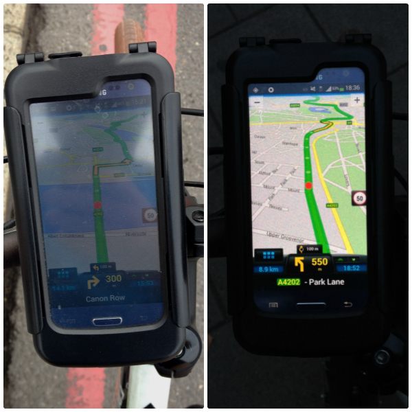
- Pictorial maps are downloaded/bought as necessary. With CoPilot, I downloaded GB and Ireland at home. It was a 350+ MB download, and it is stored on my phone. Obviously you need space for the maps, but once they are downloaded, they’re on your device and you just need GPS enabled and away you go! No more downloading of maps on the go!
- CoPilot is not aware of all the bicycle specific Sustrans pathways. This is a blessing and a curse. It is a blessing because most of the Sustrans bicycle pathways are the old “London Network” which is (for lack of a better phrase) old and knackered. The bicycle network travels round a myriad of backroads, most of which have been badly butchered by works to underground pipes which have been badly patched and unfixed potholes which are not given any sort of priority by local authorities to fix. Not to mention, a lot of the London Network wasn’t taken into account by local authorities when minor roads were redeveloped, so a cyclist following the London Network will regularly encounter dead ends and a plethora of anti-cyclist street furniture designed to make you dismount. This may be acceptable to some, but when I have an hour to make my way over to Wembley from Peckham, what I need is the most direct route, avoiding backroads and canal towpaths. CoPilot gladly obliges and presents me with a nice, straightforward route.
- Map colours – these are changeable and there is a good selection of contrast and colour settings that work well in the daytime whilst others work better when it’s dark. Furthermore, the app changes the map style over when it gets dark, which is a nice little added bonus.
- The app feels like a proper SatNav. I’ve been in the passenger seat, acting as navigator for many long car journeys and have watches the SatNav for hours on end, sometimes compensating for it, or keeping the driver informed so they don’t have to look over. CoPilot mirrors that well, warning of when a turn is coming up and overall doing a good job of being more informative than Google Maps.
Disadvantages of CoPilot are as follows:
- CoPilot is not aware of all the bicycle specific Sustrans pathways. I explained in the advantages list why this is good. Here I’ll explain why this is not so good. Some of the newer bicycle specific road developments are actually a welcome route to take. In particular, when I was making my way home from a client in Poplar through Tower Bridge, I wanted to use the CS3 (Cycle Superhighway 3) which nicely links Poplar and Tower Bridge with a dedicated blue path. As far as CoPilot was concerned, it dindn’t exist. I actually kept CoPilot on and followed CS3 and every few seconds the app would recalculate and try to send me off the CS3.
- The estimated journey time is almost exactly half of my real journey time. I am by no means a fast cyclist, whilst also being one of the cyclists that can make good headway and I do overtake 50-60% of cyclists on the road consistently. So I am somewhere in the middle of the group. Still, being told that I can traverse 13 miles over a bridge, through Victoria and Hyde Park and end up in Wembley in 27 minutes… come on! It would be good if the app either learned what my average speed is as I went alone and intelligently adjusted the estimated journey time based on this, that would be an added bonus.
So, to sum up – the paid CoPilot app does offer some nice features, straightforward journeys and the maps are stored on the device. At the same time, I haven’t deleted Google Maps, because every once in a while, when I want to use the old cycle network or make my way onto a Cycle Superhighway, I’ll power up Google Maps and use that!
Copilot gets 3 out of 5 stars